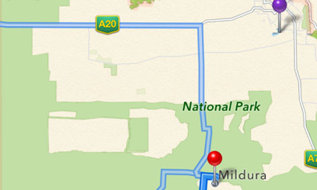
One day after police in Victoria, Australia issued a warning about Apple’s iOS 6 Maps app, advising motorists not to rely on the app for directions to the town of Mildura, due to an error in the maps data that placed the town incorrectly and caused motorists to becomes stranded in a remote area of a national park, Apple has fixed the error.

The error placed the town of Mildura some 45 miles away from its actual location and led to numerous motorists being stranded. The Victoria police responded by describing using the app to navigate as “potentially life-threatening.”
While the label on Apple’s maps has not yet been updated to show the correct location of Mildura, searches for and directions to the town now show the proper location.
It seems the error cannot be laid completely at the feet of Apple however, as The Register reports the incorrect location was included in the official Australian Gazetteer.
In this case, the Australian Gazetteer – the authoritative list of 300,000-plus placenames, complete with coordinates – includes two Milduras. One is the “real” town, the other is an entry for “Mildura Rural City”, coordinates -34.79724 141.76108. It’s this second entry that points to the middle of the Murray-Sunset National Park, just near a spot called Rocket Lake.
The report says that the second point is the one that Apple associated with searches for Mildura, and is simply the geographic center of the area within the Mildura Rural City, and doesn’t correspond to the actual city of Mildura.


